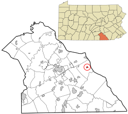
East Prospect, Pennsylvania
East Prospect, Pennsylvania | |
|---|---|
 | |
 Location in York County and the U.S. state of Pennsylvania. | |
| Coordinates: 39°58′17″N 76°31′14″W / 39.97139°N 76.52056°W | |
| Country | United States |
| State | Pennsylvania |
| County | York |
| Settled | 1849 |
| Incorporated | 1873 |
| Government | |
| • Type | Borough Council |
| • Council President | Mick Regel[1] |
| • Mayor | Kim Godfrey[1] |
| Area | |
• Total | 0.32 sq mi (0.83 km2) |
| • Land | 0.32 sq mi (0.83 km2) |
| • Water | 0.00 sq mi (0.00 km2) |
| Elevation | 587 ft (179 m) |
| Population | |
• Total | 934 |
| • Density | 2,918.75/sq mi (1,128.27/km2) |
| Time zone | UTC-5 (Eastern (EST)) |
| • Summer (DST) | UTC-4 (EDT) |
| Zip code | 17317 |
| Area code | 717 |
| FIPS code | 42-21728 |
| Website | epboro |
East Prospect is a borough in York County, Pennsylvania, United States. The population was 932 at the 2020 census.[4] It is part of the York–Hanover metropolitan area.
Geography
[edit]East Prospect is located at 39°58′17″N 76°31′14″W / 39.97139°N 76.52056°W (39.971506, -76.520601)[5] and is situated on the west bank of the Susquehanna River opposite Washington Boro. The head end of the Amerindian-named Conejohela Valley (extends to the Chesapeake) and commercially developed dam-created Lake Clarke region[6] are centered mid-river between the towns, and on a line, more or less from the two county capitals, York and Lancaster, which are also approximately equidistant.[7] The borough is surrounded by Lower Windsor Township and is just west of the Susquehanna River.
According to the United States Census Bureau, the borough has a total area of 0.3 square miles (0.78 km2), all land.
Demographics
[edit]| Census | Pop. | Note | %± |
|---|---|---|---|
| 1880 | 250 | — | |
| 1890 | 261 | 4.4% | |
| 1900 | 292 | 11.9% | |
| 1910 | 316 | 8.2% | |
| 1920 | 327 | 3.5% | |
| 1930 | 391 | 19.6% | |
| 1940 | 419 | 7.2% | |
| 1950 | 500 | 19.3% | |
| 1960 | 623 | 24.6% | |
| 1970 | 547 | −12.2% | |
| 1980 | 529 | −3.3% | |
| 1990 | 558 | 5.5% | |
| 2000 | 678 | 21.5% | |
| 2010 | 905 | 33.5% | |
| 2020 | 932 | 3.0% | |
| 2021 (est.) | 930 | [4] | −0.2% |
| Sources:[8][9][10][3] | |||
As of the census[9] of 2000, there were 678 people, 258 households, and 198 families residing in the borough. The population density was 1,918.4 inhabitants per square mile (740.7/km2). There were 272 housing units at an average density of 769.6 units per square mile (297.1 units/km2). The racial makeup of the borough was 99.41% White, and 0.59% from two or more races. Hispanic or Latino of any race were 1.18% of the population.
There were 258 households, out of which 40.7% had children under the age of 18 living with them, 64.0% were married couples living together, 8.1% had a female householder with no husband present, and 22.9% were non-families. 18.2% of all households were made up of individuals, and 7.4% had someone living alone who was 65 years of age or older. The average household size was 2.63 and the average family size was 2.97.
In the borough the population was spread out, with 28.5% under the age of 18, 5.6% from 18 to 24, 35.4% from 25 to 44, 18.6% from 45 to 64, and 11.9% who were 65 years of age or older. The median age was 33 years. For every 100 females there were 103.6 males. For every 100 females age 18 and over, there were 100.4 males.
The median income for a household in the borough was $41,250, and the median income for a family was $48,051. Males had a median income of $32,734 versus $23,036 for females. The per capita income for the borough was $16,787. About 1.4% of families and 4.9% of the population were below the poverty line, including 2.6% of those under age 18 and 6.3% of those age 65 or over.
Education
[edit]East Prospect is served by the Eastern York School District. Canadochly Elementary School is located in the borough.
References
[edit]- ^ a b "Administration". epboro.com. Retrieved April 4, 2024.
- ^ "ArcGIS REST Services Directory". United States Census Bureau. Retrieved October 12, 2022.
- ^ a b "Census Population API". United States Census Bureau. Retrieved October 12, 2022.
- ^ a b "City and Town Population Totals: 2020-2021". Census.gov. US Census Bureau. Retrieved July 8, 2022.
- ^ "US Gazetteer files: 2010, 2000, and 1990". United States Census Bureau. February 12, 2011. Retrieved April 23, 2011.
- ^ see Safe Harbor Dam
- ^ Name search and Conejohela map showing both.
- ^ "Census of Population and Housing". U.S. Census Bureau. Retrieved December 11, 2013.
- ^ a b "U.S. Census website". United States Census Bureau. Retrieved January 31, 2008.
- ^ "Incorporated Places and Minor Civil Divisions Datasets: Subcounty Resident Population Estimates: April 1, 2010 to July 1, 2012". Population Estimates. U.S. Census Bureau. Archived from the original on June 11, 2013. Retrieved December 11, 2013.


